Pro Topographical Surveyors in Clevedon
Enquire Today For A Free No Obligation Quote
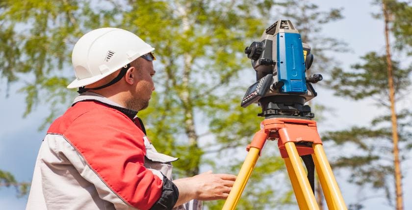
At Pro Topographical Surveyors, we specialise in precise surface mapping and terrain modelling across Clevedon and the wider UK. Using high-accuracy total stations, GNSS systems, and 3D scanning tools, we capture the full physical and structural context of land and built environments.
Pro Topographical Surveyors survey packages include customisable outputs from annotated CAD site plans to 3D terrain model, supported by expert data interpretation and consultation. Whether for planning, design, or construction, our topographical services provide clear, accurate data for safe and efficient project delivery.
How Does Topographical Surveying Work in Clevedon?
A survey by our pro topographical surveyors in Clevedon involves capturing surface-level data using precision instruments such as total stations and GPS receivers.
We measure levels, boundaries, features, and surface changes to create accurate digital terrain models or site plans.
Surveys are configured for your specific project needs, providing detailed, georeferenced outputs that integrate seamlessly with design, planning, or construction workflows.
What Services Are Included in a Topographical Survey in Clevedon?
Our pro topographical surveyors’ service in Clevedon includes:
- Initial planning and site walkover – Assessing site conditions, access, and scope of survey.
- Instrument setup – Deploying total stations, GNSS, or scanners based on project accuracy and scale.
- Detail and level capture – Recording terrain, surface features, boundaries, and structural elements.
- On-site data collection – Gathering horizontal and vertical point data across the site.
- Data processing and refinement – Converting field data into clean, usable formats.
- Mapping and plan production – Generating CAD drawings, contour maps, or 3D models.
- Custom deliverables – Outputs tailored for planning applications, design, or BIM use.
- Summary report – Overview of survey parameters, results, and any project considerations.
How Much Does a Topographical Survey Cost in Clevedon?
The cost of a topographical survey by Pro Topographical Surveyors in Clevedon ranges from £450 to over £2,000, depending on site size, complexity, and deliverables.
Costs are influenced by terrain conditions, vegetation cover, the need for 3D outputs, and whether urgent scheduling or additional services are required.
Contact Pro Topographical Surveyors in Clevedon to get customised prices for topographical surveying at your site.
When Should You Use Topographical Surveying Services in Clevedon?
Our pro topographical surveyors in Clevedon recommend surveys prior to design, planning, or site development.
They are essential for setting out buildings, modelling terrain, calculating earthworks, assessing site suitability, or updating outdated records. Common applications include construction planning, road and drainage design, landscaping, and architectural layouts.
What Equipment Is Supplied for Topographical Surveys in Clevedon?
Our pro topographical surveyors operate with advanced survey technology in Clevedon, including:
- Dual-frequency GNSS units – For accurate geospatial referencing and control.
- 3D laser scanners – Capturing detailed spatial data and point clouds for complex environments.
- Aerial survey drones (UAVs) – Used for large-area coverage and elevation modelling.
- Rugged data loggers and controllers – For secure and reliable data collection in field conditions.
- Survey software and CAD platforms – For producing annotated plans, models, and terrain profiles.
How Accurate Are Topographical Surveys in Clevedon?
Our pro topographical surveyors in Clevedon deliver typical accuracy of ±5 mm for control points and ±10–20 mm for general features, depending on equipment and site conditions.
We follow best practices for calibration, control establishment, and data verification—ensuring results meet the standards expected by engineers, planners, and architects.
Can Topographical Surveys Be Carried Out in All Clevedon Environments?
Our pro topographical surveyors in Somerset conduct surveys across open fields, urban environments, industrial sites, construction zones, and vegetated terrain.
Survey methodology and equipment are adapted to match each setting—ensuring complete and reliable coverage regardless of ground conditions or access constraints.
What Deliverables Are Provided After a Topographical Survey in Clevedon?
Clients working with our pro topographical surveyors in Clevedon receive:
- Annotated CAD site plans – Showing levels, features, boundaries, and services.
- Contour maps – Highlighting elevation and surface gradient across the site.
- 3D digital terrain models – For visualisation, planning, or engineering use.
- Boundary overlays and spot levels – For planning and site referencing.
- PDF and DWG file formats – Ready for design and planning use.
- BIM-compatible outputs (if required) – Including Revit or Civil 3D formats.
- Georeferenced datasets – All files aligned to coordinate grids or control networks.
What Standards and Safety Measures Are Followed During Topographical Surveys in Clevedon?
Our pro topographical surveyors in Clevedon follow national surveying standards and adhere to CDM and site-specific health and safety protocols. This includes hazard assessments, PPE use, controlled access zones, and equipment safety procedures.
All survey activity is recorded, and digital logs are maintained for traceability and client assurance.
Contact Pro Topographical Surveyors for a consultation on topographical surveying at your property.
Find More Info
Make sure you contact us today for a number of great topographical survey services in South West.
Here are some towns we cover near Clevedon BS21 6
Nailsea, Portishead, Avonmouth, Weston-Super-Mare, BarkingFor more information on topographical surveys in Clevedon BS21 6, fill in the contact form below to receive a free quote today.
★★★★★
We chose Pro Topographical Surveyors for a topographical survey and they didn’t disappoint. Timely, reliable, and precise.
Grace Cook
Somerset
★★★★★
Pro Topographical Surveyors provided everything we needed to move forward with planning. Excellent drawings and service.
Emily Edwards
Somerset